
A Guide to the Archaeology of Conflict
© T.L.Sutherland 2005
Methods of evalation
Those who study battlefield archaeology need to use a multidisciplinary array of techniques in order to locate physical evidence of conflict. Each site will have its own idiosyncratic type of evidence depending upon what period is being represented. However, it is important to reiterate that the relevant surveys and any resulting interpretation should always be undertaken by experts in the use of a particular type of analysis and thus interdisciplinary team work is often the best way to gain the greatest amount of information on these sites.
Earthwork surveys
Earthworks on battlefields will vary greatly depending upon which period is under investigation. Medieval open battlefields, for example, generally exhibit few, if any earthworks that were constructed for use during the battle, whereas those from the First World War often exhibit extensive evidence of trenches, underground tunnel systems, and mines excavated under enemy trenches. Standing earthworks should therefore be analysed in order to hopefully typologically identify, date them or even eliminate them from the investigation. First World War trenches, for example, were constructed for troop movement along the lines and generally exhibit a zigzag type plan. They were constructed in this manner to prevent shell blasts from travelling down the trench. Second World War fox holes however, were usually constructed by, and for an individual soldier in which to shelter during an advance or in defence of an area. These usually consisted of simple, small and shallow, irregularshaped pits. Types of these earthworks can also be found on contemporary or now redundant Ministry of Defence training sites across Britain. Their counterparts, used during combat, can still be found across battlefields in various parts of the world.
Geophysical Survey
There are several types of geophysical survey instruments used by battlefield archaeologists. Most of these instruments work by identifying the difference between an anomaly under investigation (a metal artefact, a ditch or a wall) and the background material in which the anomaly is located. A general guide to Geophysical Techniques in Archaeological Evaluations can be found in IFA Paper No. 6 (Gaffney et al 2002)
Metal Detector Survey
The most commonly used instrument within battlefield archaeology is the electronic conductivity meter more commonly known as a Metal Detector. It uses an induced magnetic field to exhibit the location of fragments of metal within the locality of the search head. It does not, however, generally incorporate a logging device to record the instrument readings. The standard device generally works to a maximum depth of around 20-30cm for an object the size of an average coin, although this varies greatly depending upon the type and quality of instrument used.
The metal detector or electromagnetic conductivity meter, although in common use by the general public, is a sophisticated prospection or geophysical survey instrument. When handled by an experienced practitioner it can be used to locate minute fragments of metal and potentially identify the metal type without the need for excavating the artefact. However, in inexperienced hands misleading information can be recorded or missed entirely, leading to incorrect interpretations of a sites archaeological potential. It is therefore essential that an experienced practitioner should always carry out the metal detection investigation rather than, for example, an archaeologist who is not skilled in the use of a metal detector. Ideally, the practitioner should incorporate all of the skills necessary to record a site of conflict. Teams of metal detectorists and archaeologists working together are possibly the best way of analysing a site of conflict, although detectors of a similar type cannot be used in close proximity as they will interfere with each other. The use of groups of detectors, however, requires a commitment in terms of the necessary resources and so it should not be undertaken lightly. At the Little Bighorn battlefield, USA (1876) Scott et al (1989, 25) state that
The use of metal detectors operated by knowledgeable people has overwhelmingly proved its value, in locating not only metal objects but also non-metallic remains. Scores of non-metallic items such as bone, leather, rubber articles, and shell buttons, were found when metal detectors sensed nearby metal objects. Our recovery methods, which meticulously uncovered artefacts without disturbance, were an integral part of the field procedures .We have repeatedly emphasized, though, that when taken out of context the scientific value of artefacts is seriously impaired.
 |
| Plate 11: |
Signage close to the Chickamauga Battlefield Visitor Centre, Tennessee, USA |
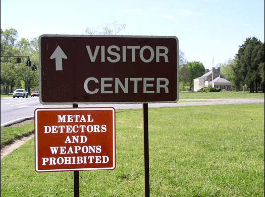
It is therefore essential that all of the archaeological information associated with each artefact is recorded at all times by those carrying out the investigation. The irresponsible use of a metal detector on sites of former conflict should therefore be regarded as totally unacceptable. An American sign on a site of conflict goes as far as to associate metal detectors with other tools of potential destruction (Plate 11).
Fluxgate Gradiometer or Magnetometer
These instruments record differences in the distortion of the earths magnetic field across a given area. They can be used as a crude ferrous metal detector as they record ferrous spikes when a piece of ferrous metal is in close proximity to the instrument. However, such surveys have been carried out and found to be only relatively useful. At Towton, for example, fluxgate gradiometer surveys carried out over an area of known medieval arrowheads (Plate 12) failed to identify the locations of most of these artefacts due to the natural replacement over time of their ferrous component by mineralised products (Sutherland forthcoming).
 |
| Plate 12: |
Medieval arrowheads discovered during the Towton Battlefield Archaeological Survey(© Royal Armouries 2004) |
The fluxgate gradiometer is best used for locating sub-surface archaeological features, such as ditches or fired features, such as hearths or kilns. The instrument generally incorporates a logging device to record the instrument readings. It is generally effective to a depth of around 50cm depending upon the strength of the magnetic disturbance. For example, a wire fence or a large ferrous anomaly such as a car will affect the instrument from several metres away, disguising fainter readings that lie within a closer distance.
Electrical Earth Resistance Meter
The electrical earth resistance meter records the difference in the electrical conductivity or moisture content of the soil. Damp ditch fills or dry walls exhibit themselves against a background that is different to that of the archaeological feature. The instrument generally incorporates a logging device to record its readings. It is generally very effective at depths of less than 50cm. It can be used to located graves only when the grave fill exhibits a different moisture content to that of its surroundings. As a grave usually consists of a hole into which the material which was excavated from it is re-deposited within a short space of time, it has been shown that such graves are rarely identifiable on earth resistance surveys. Only when burial is relatively recent is such a grave usually apparent (Lynam 1970)
Ground Penetrating Radar (GPR)
As the name suggests, ground penetrating radar sends out a signal from a transmitter (usually into the ground) and records a reflected signal via a receiver. Although due to its complicated nature the received signal is very difficult to interpret, the instrument can be effective up to several metres in depth. However, as with other prospection instruments, the anomaly under investigation would have to be sufficiently distinct from the surrounding material for this to be observable.
Field Walking
Field walking surveys are carried out by walking across the surface of a piece of ground looking for any manmade artefacts. The locations of these artefacts are recorded either precisely, using a total station, or more commonly within a gridded square in which they were found. The artefacts can then be either collected, or analysed in situ and then left on the surface so that their context remains undisturbed.
Field walking surveys can cover large areas of land with minimal equipment or technical expertise, although the setting out of a very accurate grid prior to the survey is very important. The more people that carry out the survey the faster the ground will be covered, although the accuracy of the results will then depend upon the productivity and capabilities of each person.
Such surveys have been carried out across a number of battlefields with varying degrees of success. As stated above, Peter Newman conducted an excellent survey in the 1970's on the battlefield at Marston Moor, Yorkshire (1644).
Destktop Assessments
A desk-based or desk-top assessment is simply a search through as much of the available literature and documents that relate to the site or period in question as possible. These are usually maps, aerial photographs, historical documents such as primary sources and histories or secondary sources. Such information is generally available in libraries and archives or record offices around the world.
An important point to note regarding battlefield studies is that the outcome of many battles had international repercussions. Many foreign archives therefore hold documents that are pertinent to conflicts outside their own borders. Following the battle of Towton (1461) for example, letters were passed around Europe informing interested parties that England had a new Yorkist monarch (Hinds 1912).
Another source of information involves the old Sites and Monuments Records (SMRs) or as they are now termed the Historical Environment Records (HERs). These are the records of particular sites, artefacts or areas of historical or archaeological interest, which are normally held on a regional basis within a local records office.